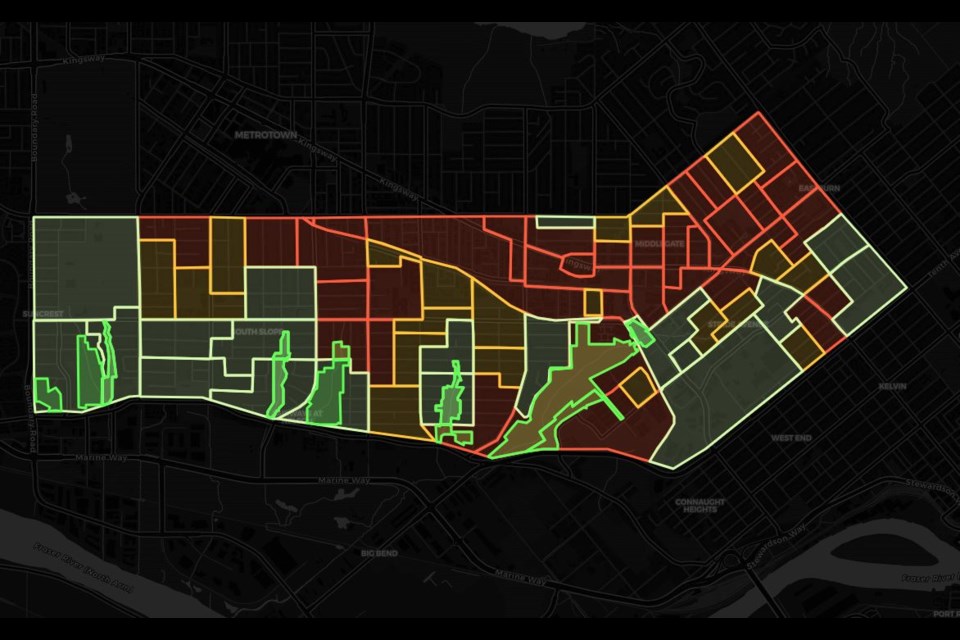
When you hover over Thierry Haddad’s colourful map of South Burnaby, a symphony of sound and noise emerges.
The red sections conjure a cacophony of revving cars and backing-up dump trucks.
Move to the green zones, and you hear sparrows singing and chickadees chirping.
Burnaby resident Haddad created the interactive map as part of a project tracking and charting noise in South Burnaby.
Though the Citrus Index project, Haddad has collected around 280 hours of data on local noises as indicators of environmental conditions.
The goal is to generate environmental data that can allow people to assess how well the city is growing, Haddad told the Burnaby NOW.
“It’s like taking the pulse of the neighbourhood,” he said.
“My main goal is just to collect the data and see what comes out of it.”
Most of the sounds come from cars and the SkyTrain tracks, Haddad noted.
Haddad used the actual South Burnaby sounds, not stock audio, recorded in his surveys to create the interactive map.
Haddad, who has lived in Burnaby for 15 years and has worked in finance and computer programming, wanted to start a “meaningful project” three years ago.
“I finally decided to take a chance and give my idea a try.”
Songbird data
Haddad said the data can test the health of urban wildlife, such as songbirds, in an area.
Birds are very sensitive to changes in their environment, Haddad said, and can be tracked by the absence or presence of their song.
And if the sound recordings are frequent enough, people could anticipate the environmental changes before they occur, he added.
“If we’re not managing that growth properly, the songbirds will tell us.”
“(The birds are) a good indicator to see how much progress we’re doing, and how well we’re driving that growth and change.”
180 hours of unmanned observations at 40+ locations have begun to unveil interesting trends. Stay tuned for analysis! But for now, enjoy this picture of this Stellar Jay. pic.twitter.com/c73Hbw6Xl6
— citrusindex (@thierrytheg) August 23, 2023
Haddad went into the experiment with as few assumptions as possible, he said.
What surprised him was how quiet parts of the city are.
“I know that it gets busy, Rumble (Street) gets busy, the main arteries. … But the big wake-up call for me was the discrepancy between the sound level in different parts of the city,” he said.
In an account of his findings posted online, Haddad noted many of the louder parts of the city plot onto the same areas where renters live.
“The quietest neighbourhoods have the lowest tenant density while the majority of the noisiest neighbourhoods have a high tenant density,” wrote Haddad in the article.
He reminded readers that correlation isn’t causation but added the data suggests renters are more likely to be exposed to urban noises than single-family homeowners.
Haddad was quick to note he’s not an urban planner and didn’t want to speculate too much on possible data analyses.
“I leave that to people who are more keen on that kind of work,” he said. “Like I said, I just do the data … and try to make it engaging and interactive.”
He has spoken with researchers on noise who have suggested vehicle speeds can cause noise, as well as the state of the roads.
Smartphones collect data
Haddad, a self-proclaimed geek, collects the sound data using smartphones hidden in select locations throughout South Burnaby.
The phones run for about 10 to 12 hours on their own and log the data to an app Haddad created.
The app uses machine learning to recognize specific sounds.
Haddad runs a timer for when to pick the phones up, then takes them home, recharges them, extracts the data and sets them up again the next day.
.png;w=960)
So far, Haddad has been lucky – none of the phones have been stolen.
But he hides them well, he added, in enclosures made out of wood.
He said the project has allowed him to discover parts of South Burnaby he hadn’t seen before.
“I had the model; I had the hardware, and I had the skills to write the app, write the code to analyze the data. And then I had my feet and a bicycle, so I could just get around the city and record those sounds wherever I went.”
He’s hoping to eventually repurpose old smartphone batteries so the phones can have a longer life and upload the data to the cloud, allowing people to access it in real time.
Haddad pointed to the Port of Vancouver’s live noise monitoring map as an example.
Citizen science
Haddad noted the project is citizen-led and not funded by the city or any private business.
He said he wants to make the data available to the public to have support for social change, instead of just basing observations on anecdotes.
“I was just wondering one day, how easy it would be to collect noise data around South Burnaby, and how you could leverage the data to make change happen.”
He added he’s not against growth, but it’s about the kind of city Burnaby – or any growing city – wants to become.
Haddad said it’s about looking for innovative ways to collect data and making it publicly accessible.
“(I want to) make it available to the community, for anybody who might have an interest in the data,” he said.
“It is for everybody to benefit.”


