The monthly Burnaby RCMP crime bulletin has arrived and it has some revealing things about a certain neighbourhood.
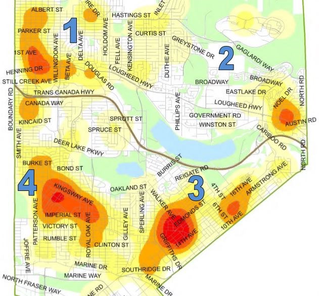
The bulletin always include several maps showing where break-and-enters and vehicle-related thefts are taking place. It also includes that heat map that shows the crime hot spots based on recent reports.
The big red spot is usually centered around the Metrotown area, but South Burnaby’s Edmonds area has suddenly appeared.
Edmonds is one of the four “city centres” and the crime bulletin’s latest heat map has a big, red circle right in the middle of it.
You can see the heat map attached to this blog.

I love Edmonds. I used to live in the High Gate area and made several friends in the area. But it’s also insanely busy. There were also a lot of shady types that made walking to the High Gate shopping centre at night a little dicey.
It’s a big reason why I moved to Burnaby Mountain – I was searching for some peace and quiet.
Sometimes, however, I must the hustle and bustle. And the good restaurants, although I fear many of them will never reopen again due to the COVID-19 pandemic.
These crime heats maps are interesting to study month by month. Metrotown will also be in dark red, but you see crime shift to other areas. Even beloved Burnaby Mountain landed a bright orange blob due to a rash of break-ins a few months ago.
This latest one also doesn't look good for the businesses bordering North Road, just south of Lougheed Highway. The colour is pretty red due to business break-and-enters.
Based on the other maps included in the bulletin, Edmonds has been hit by a rash of break-and-enters at businesses, as well and a flurry of vehicle thefts, and thefts from vehicles.
I tried counting all of the red dots (vehicle thefts) and green dots (thefts from vehicle), but it was too many. Folks, I know you can’t do much about having your vehicle stolen, but remember to clean out your vehicle on a daily basis after you use it because thieves will go after anything they see.
Follow Chris Campbell on Twitter @shinebox44.


